Record Detail
| t12569 | |
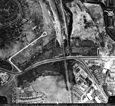
| (Centre) Herries Road showing (middle left) Scraith Wood Drive (bottom left) Oxspring Bank and Cookson Road and (bottom centre) Oxspring Dam | |
| Sheffield_Owlerton | |
| 1971/09/02 | |
| 1960-1979 | |
| Fairey Surveys Ltd. | |
| Fairey Surveys Ltd. | |
This photograph shows the area to the south of t12568 and overlapping. Top left curve of Penrith Road, north (to bottom) of it Scraith Wood Drive. Trading estates in top right quadrant between railway, Herries Road South and River Don not yet built. Scraith Wood Drive shows old road layout cleared of prefabs before new housing built in a more compact area. |
Copying and access
This digital image, and all images on Picture Sheffield, are protected by copyright. You may use it for private study or non-commercial research, with due acknowledgement.
You may share it on social media via a linked post or by citing www.picturesheffield.com together with the Image Reference, unless its copyright is noted as belonging to another organisation. You must not reproduce it by any other means without permission.
