Record Detail
Large format version available - click on Zoom button to browse this image in a zoomable viewer
| q00089 | |
| Ordnance Survey Map, sheet no. Yorkshire No. 294.11.1 | |
| Sheffield_Broomhill | |
| 1889 | |
| 1851-1899 | |
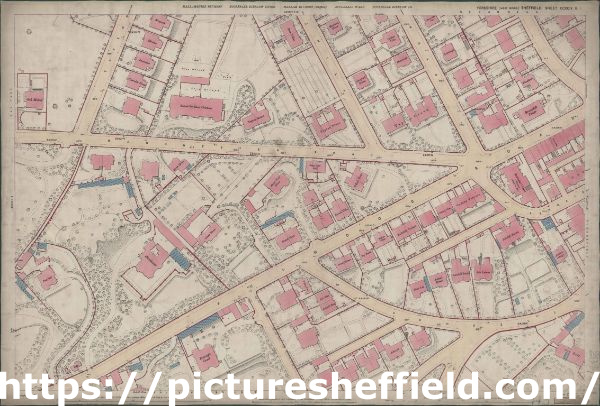
This map features: Top Left: Tapton House Road, Manchester Road, Oak Mount, Kingscote, Clivedon, Leavesdale, Clairville House, Rose Villas, Tapton Mount, School for Blind Children [Tapton Mount School for the Blind], Stand Field House, and Birch Grove. Bottom Left: Fulwood Road, Stand View, Stand House, Birchlands and Lodge, Fairfield, Endcliffe Court, Endcliffe House (in margin), and Tapton Cliffe (in margin). Top Right: Fulwood Road, Manchester Road, Sale Hill, Lawson Road, Taptonville Road, Ashgate Road, Ash Mount, [Broomhill Wesleyan Church] Methodist Chapel (Wesleyan) (on Fulwood Road), Broomhill Lodge, Woodlands, Limeleigh, Wharncliffe Villa, Brookholme, Canton Villa, Stoneleigh, Tapton Grove, Mowbray House, Alresford House, Tapton Place, Stand Field Place, Willow Bank, Stand Field, Post Office on Fulwood Road. Bottom Right: Fulwood Road, Ashdell Road, Caxton Road, Oakholme Road, Ashgate Road, Ashdell Cottage, Ash Dell, Ashcroft, Willow View, Ash Rise, Ashdell Rise, Ashdell Terrace, Standfield, Stand Villa, Ivy Bank, Willow Villas, Endcliffe Terrace, Oxford Villas, Oxford Terrace, Ashdell Mount, West Lea, Ashdell House, Ashdell Bank, Ash Lawns. Surveyed, 1889. Dimensions 77 x 102 cm. Scale 10.56 feet : 1 mile [1:500] |
Copying and access
This digital image, and all images on Picture Sheffield, are protected by copyright. You may use it for private study or non-commercial research, with due acknowledgement.
You may share it on social media via a linked post or by citing www.picturesheffield.com together with the Image Reference, unless its copyright is noted as belonging to another organisation. You must not reproduce it by any other means without permission.