Record Detail
Large format version available - click on Zoom button to browse this image in a zoomable viewer
| q00088 | |
| Ordnance Survey Map, sheet no. Yorkshire No. 294.10.10 | |
| Sheffield_Endcliffe | |
| 1892 | |
| 1851-1899 | |
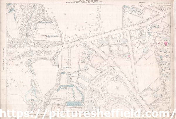
This map features: Top Left: Fulwood Road, Lodge (x 2), Oak Brook, weir, Oakbrook Farm, Endcliffe Mount, [site of Thornbury Hospital, Fulwood Road]. Top Right: Fulwood Road, Endcliffe Vale Road, nnmarked road [Woodvale Road], Shore Lane, Tapton Edge, Endcliffe Edge, Endcliffe Cottage, lodge, [Site of University of Sheffield student village]. Bottom Left: Oakbrook Farm, Endcliffe Hall, waterfall, fountain. Bottom Right: Endcliffe Vale Road, Endcliffe Hall, Endcliffe Vale House (in margin), Endcliffe Crescent (in margin), The Grove, lodge, well, Chimney. Additional information from Google Maps. Surveyed, 1892. Reprint 1895. Dimensions 77 x 102 cm. Scale 10.56 feet : 1 mile [1:500] |
Copying and access
This digital image, and all images on Picture Sheffield, are protected by copyright. You may use it for private study or non-commercial research, with due acknowledgement.
You may share it on social media via a linked post or by citing www.picturesheffield.com together with the Image Reference, unless its copyright is noted as belonging to another organisation. You must not reproduce it by any other means without permission.