Record Detail
Large format version available - click on Zoom button to browse this image in a zoomable viewer
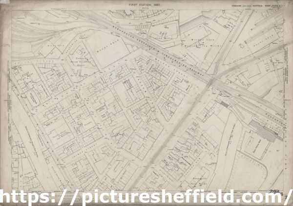
| q00078 | |
| Ordnance Survey Map, sheet no. Yorkshire No. 294.8.7 | |
| Sheffield_Wicker_area | |
| 1889 | |
| 1851-1899 | |
Surveyed in 1889. Reprinted 1903. This map features: Top left: Manchester, Sheffield and Lincolnshire Railway, Goods Shed, Brunswick Road, Andrew Street, [William Wright, mortar grinder], Nursery Steam Grinding Wheel (entrance on Brunswick Road), Spital Fields, [John Aizlewood, corn miller], Crown Corn Mills (entrance on Nursery Street), Holy Trinity School (Boys and Girls), Holy Trinity Church, Nursery Street, Nursery Lane, Johnson Street, Stanley Street, Stanley Lane, Johnson Lane, [William Briggs and Co., electroplate manufacturers], Wentworth Plate Works (entrance of Stanley Lane / Andrew Street), Albion Inn, smithy, Harlequin Inn, Manchester Hotel Public House, Bridgehouses Station, River Don, Joiner Lane, and Midland Railway Goods Line. Top right: Manchester, Sheffield and Lincolnshire Railway, Brunswick Road, Andrew Street, Wicker Lane, Wicker, Tramway, Viaduct, Scholey Street, [Walker Eaton and Co., engineers], Wicker Iron and Engineering Works (entrance at bottom of Spital Hill), [Joshua Wigfull and Sons, corn millers and corn merchants], Star Corn Mills [on Walker Street], Walker Street, Lime kilns, Travelling cranes, smithy, Station Inn, Goods shed, Wicker Station, Spital Hill,Walker Street, [Charles Drury, iron and steel merchant], Darley Works (iron and steel) (entrance at No. 6 Savile Street), [?Henry Matthews, mahogany, timber and raff merchant, Don sawing, planning and moulding mills], Don Saw Mills (entrance on Savile Street), Lodge Inn, Savile Street, Andrew Lane, Smithy, and River Don. Bottom left: Nursery Street, Nursery Lane, Johnson Street, Stanley Street, Stanley Lane, Johnson Lane, Holy Trinity Church, River Don, Nursery Street, [George L. Wood and Co.], Nursery Street Saw Mills, Joiner Lane, [Bethesda] Primitive Methodist Church (on Stanley Street), Sunday School, Joiner Street, Millsands, Foundry, Albion Works (on Nursery Lane), Railway Inn, [B and J, Wilcock, saw and machine knife manufacturers], Bolton Works (saws, machine knives, etc) (on Nursery Lane), Foundry, Crown and Anchor Public House, Wicker, tramway, Wicker Lane, New White Lion Inn, and Nursery Street Wire Works. Bottom right: Manchester, Sheffield and Lincolnshire Railway, Wicker, tramway, Wicker Lane, Scholey Street, Post Office, Victoria Station, Royal Victoria Hotel, Victoria Inn, [Louis Henry Morgan, crucible manufacturer], Crucible Works (on Wicker Lane), Sheldon Yard, Sheldon Row, Willey Street, Bull Inn, Brown Cow Public House, Bull and Oak Public House, Wicker Mortar Mills (on Sheldon Row), Falstaff Inn, [Seebohm and Dieckstahl, steel convertors and refiners], Dannemora Steel Works (on Sheldon Row), Smithfield Market (with cattle pens), Victoria Station Road, Furnival Road, and [Samuel Osborn and Co., steel manufacturers], Clyde Steel and Iron Works [on Wicker]. Additional information from White's General and Commercial Directory of Sheffield, 1896 / Graces Guide. Surveyed 1889. First edition 1890. Dimensions 77 x 102 cm. Scale 10.56 feet : 1 mile [1:500]. Original at Sheffield City Archives. |
Copying and access
This digital image, and all images on Picture Sheffield, are protected by copyright. You may use it for private study or non-commercial research, with due acknowledgement.
You may share it on social media via a linked post or by citing www.picturesheffield.com together with the Image Reference, unless its copyright is noted as belonging to another organisation. You must not reproduce it by any other means without permission.