Record Detail
Large format version available - click on Zoom button to browse this image in a zoomable viewer
| q00059 | |
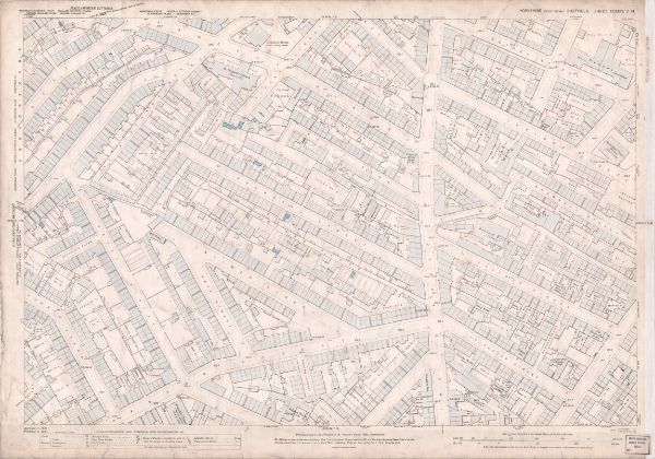
| Ordnance Survey Map, sheet no. Yorkshire No. 294.7.14 | |
| Sheffield_Netherthorpe | |
| 1889 | |
| 1851-1899 | |
This map features: Top left: Fawcett Street, Daisy Bank, Bramwell Street, Powell Street, Radford Place, Bromley Street, St. Stephen’s Road, Finlay Street, Mushroom Lane, Bellefield Street, Bellefield House (Girls Training School), Bellefield Street, Wentworth Street, [St Stephen’s National School], Finlay Street, St. Stephen’s Church, Bellefield Terrace. Top right: Fawcett Street, Daisy Bank, Bramwell Street, Radford Place, Bethel Street, St Philip’s Road, Upper St Philip’s Road, Brownell Street, Daisy Walk, [John Hartley and Sons, Cutlery Manufacturers], Daisy Works, Daisy Walk, Francis Greaves and Sons, Cutlery Manufacturers], Radford Works, Radford Street, Hammond Street, Ellison Street, Netherthorpe Street, [Netherthorpe Board School], Dover Street, Jericho Street, Primitive Methodist Chapel, Jericho Street / Hoyle Street, [James and F. C. Wild], Borusssia Steel and File Works, Jericho Street, Prince of Wales Hotel Public House, [Broompark] Mission Rooms, Sunday School, Hoyle Street, Well Meadow Street, Jericho Square, Victoria Hotel Public House. Bottom left: Powell Street, Radford Place, Latimer Street, Weston Street, [Robert Lingard], Cutlery Works, The Mount, Radford Place, Bathfield Place, Summer Street, Hope Street, Weston Street Methodist Chapel (Wesleyan Reform), Weston Terrace, [Stephen Fisher and Co., malleable iron castings], Pelham Works, Mitchell Street, Steel Works, Westgrove Square. Bottom right: Radford Place, Latimer Street, Weston Street, Cutlery Works, St Philip’s Road, Upper St Philip’s Road, Brownell Street, Daisy Walk, Francis Greaves and Sons, Cutlery Manufacturers], Radford Works, Radford Street, Radford Street, Steam Fly Works (cutlery), Radford Street, Leicester Street, Corn Hill, Upper Allen Street, Brightmore Street, [possibly George R. Townend], Albany Works (edge tools), Radford Street, Cutlery Works, Old Brown Cow Public House, Smithy, Falcon Inn, Leicester Street, Leicester street Foundry (iron), [Brookes and Crookes], Atlantic Works (cutlery), Upper St Philip’s Road, Salutation Inn, Nevada Works (silver), No. 33 Leicester Street, [James Burnand and Sons, cutlery manufacturers], Leicester Works, Leicester Street, New Edward Street, The Albion Public House, Radford Lane. Additional information from White's General and Commercial Directory of Sheffield, 1896 / Graces Guide. Surveyed 1889. Published 1890. Dimensions 77 x 102 cm. Scale 10.56 feet : 1 mile [1:500]. Original at Sheffield City Archives. |
Copying and access
This digital image, and all images on Picture Sheffield, are protected by copyright. You may use it for private study or non-commercial research, with due acknowledgement.
You may share it on social media via a linked post or by citing www.picturesheffield.com together with the Image Reference, unless its copyright is noted as belonging to another organisation. You must not reproduce it by any other means without permission.