Record Detail
Large format version available - click on Zoom button to browse this image in a zoomable viewer
| q00057 | |
| Ordnance Survey Map, sheet no. Yorkshire No. 294.7.13 | |
| Sheffield_Upperthorpe | |
| 1889 | |
| 1851-1899 | |
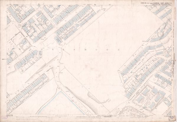
This map features: Top left: Crookesmoor Road, Elliot Road, Burns Road, Barber Road, Vincent Road, Hadfield Hotel Public House, Moor Edge, Ivy Cottage, Oxford Street, St. John’s Wesleyan Chapel [on Crookesmoor Road], Manor View, Prospect Terrace, Post Office [on Crookesmoor Road]. Top right: Wentworth Street, Bromley Street, Canada Road, East Mushroom Lane, School playground [on Crookesmoor Road], Oxford Street, [The Ponderosa]. Bottom left: Crookesmoor Road, Great Dam Road, Old Great Dam [reservoir] Sheffield Waterworks), Harcourt Road, [Crookes Valley Road]. Bottom right: Bromley Street, Canada Road, East Mushroom Lane, Great Dam Road, Winter Street, Borough Fever Hospital [Winter Street Hospital], Westgrove Square. Surveyed 1889. Reprinted 1901. Dimensions 77 x 102 cm. Scale 10.56 feet : 1 mile [1:500]. Original at Sheffield City Archives. |
Copying and access
This digital image, and all images on Picture Sheffield, are protected by copyright. You may use it for private study or non-commercial research, with due acknowledgement.
You may share it on social media via a linked post or by citing www.picturesheffield.com together with the Image Reference, unless its copyright is noted as belonging to another organisation. You must not reproduce it by any other means without permission.