Record Detail
Large format version available - click on Zoom button to browse this image in a zoomable viewer
| q00048 | |
| Ordnance Survey Map, sheet no. Yorkshire No. 294.7.2 | |
| Sheffield_Walkley | |
| 1889 | |
| 1851-1899 | |
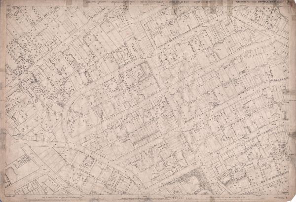
This map features: Top left: Fir Street, Hadfield Street, Fir Spring House, Cundy Street, South Road, St. Mary's Church [Walkley], Grove Terrace, Eveline Terrace, Olivet Mount, Lorne House, The Grove, Chestnut House, Astley House, Greenhow Street, St. Mary's School, South Road, and Mount Pleasant. Top right: The Grove, Cundy Street, South Road, Duncombe Street, Cromwell Street, Walkley Street, Burgoyne Road, Hadfield House, Albert House, Old quarry. Bottom left: Hadfield Street, Highbury, Matlock Road, Heavy Gate Road, Duncombe Street, Cromwell Street, Aldred Road, Bradley Street, Alma House, and Wesleyan Methodist Chapel [Mount Olive Wesleyan Chapel]. Bottom right: Duncombe Street, Cromwell Street, South Road, Fulton Road, Howard Road, Howard Cottage, Clifton House, Birkendale, Highview Cottage, Birkendale Cottage, Howard Hotel, Thrybergh Terrace, St. Joseph's Home School (Boys and Girls) / Industrial School for Catholic Girls, Western Cottage, Sherwood Cottage, Beech House, Daniel's Terrace, and Elm Cottage. Dimensions 77 x 102 cm. Scale 10.56 feet : 1 mile [1:500]. Original at Sheffield City Archives. |
Copying and access
This digital image, and all images on Picture Sheffield, are protected by copyright. You may use it for private study or non-commercial research, with due acknowledgement.
You may share it on social media via a linked post or by citing www.picturesheffield.com together with the Image Reference, unless its copyright is noted as belonging to another organisation. You must not reproduce it by any other means without permission.