Record Detail
Large format version available - click on Zoom button to browse this image in a zoomable viewer
| q00041 | |
| Ordnance Survey Map, sheet no. Yorkshire No. 294.4.18 | |
| Sheffield_Burngreave | |
| 1889 | |
| 1851-1899 | |
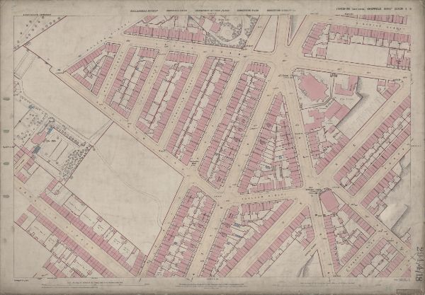
This map features: Top left: Earldom Street, Grimesthorpe Road, Lyons Road, The Hills, Malton Street, Burngreave Cemetery, Hooton Street, Lucas Street, Normanton Street. Bottom left: Earldom Street, Grimesthorpe Road, Danville Street, Danville Terrace, Normanton Hotel Public House, Catherine Road, Buckenham Road, Brighton Villas, Rose Terrace, Regent Villas, Hopewell Villas, Albert Villas, Ellesmere Road. Top right: Lyons Road, Grimesthorpe Road, Ellesmere Road, Broom Ley, Sedan Street, Kingston Street, Lyons Street Sutherland Road, Petre Street, Edgar Street, Horbury Vilas, Kingston Place, All Saints Church [All Saints School, Burngreave], Playground, York Villas, Carlton Villas, Bamford Villas, Gladstone Grove, Kingston Villas, Clifton Place, Clinton Place, Sutherland Place. Bottom right: Ellesmere Road, Sutherland Road, Petre Street, Edgar Street, Gladstone Grove, Kingston Villas, Earldom Street, Harlestone Street, Earsham Street, Thorndon Road, Writtle Street, Earldom Place, Belgrave Villas, Ellesmere Villas, Primitive Methodist Chapel [Petre Street Methodist Church]. Dimensions 77 x 102 cm. Scale 10.56 feet : 1 mile [1:500]. Original at Sheffield City Archives. |
Copying and access
This digital image, and all images on Picture Sheffield, are protected by copyright. You may use it for private study or non-commercial research, with due acknowledgement.
You may share it on social media via a linked post or by citing www.picturesheffield.com together with the Image Reference, unless its copyright is noted as belonging to another organisation. You must not reproduce it by any other means without permission.