Record Detail
Large format version available - click on Zoom button to browse this image in a zoomable viewer
| q00040 | |
| Ordnance Survey Map, sheet no. Yorkshire No. 294.4.17 | |
| Sheffield_Burngreave | |
| 1889 | |
| 1851-1899 | |
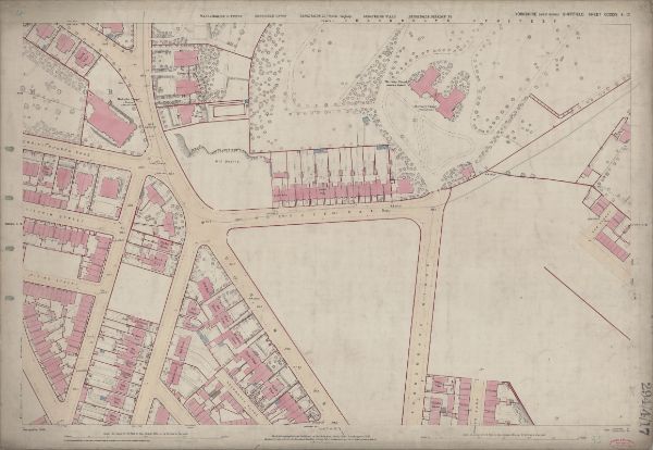
This map features Top left: Minna Road, Burngreave Road, Melrose Road, Fox Street, Pilgrim Street, Melrose Villas, [Burngreave Road Wesleyan Chapel] Methodist Chapel (at junction of Burngreave Road and Christ Church Road), Brook Villas, Wood Bank, Lea Wood, old quarry, Christ Church Road, Hope Villa, Malton Villas, Burngreave Cemetery. Top right: Melrose Road, Melrose Villas, Burngreave Street, Sun Street, Mortuary Chapel (C of E), Mortuary Chapel (Non-conformist), Burngreave Cemetery. Bottom left: Minna Road, Burngreave Road, Fox Street, Rock Street, Rising Street, Carlton House, Rock End, Fox Street, Cranworth Place, Brotherton Street, Nottingham Street, Cranworth Road, Claremont Villa, Manor View, Elm Villas, Thorne Place, Thornton Place, Bank View, Carlton Place, Baines Place, Rock Rise, Ash Mount, Elm Cottage, Rock Cottage, Wood View, Woodview House, Clyde Place, Brotherton Place, Rock Terrace, Beech View, Augusta Villas, [Nottingham Cliff?] Recreation Ground. Bottom right: Burngreave Street, Hebden Villas, Hebden House, Sun Street, Burngreave Bank, Danville Terrace, Danville Street. Dimensions 77 x 102 cm. Scale 10.56 feet : 1 mile [1:500]. Original at Sheffield City Archives. |
Copying and access
This digital image, and all images on Picture Sheffield, are protected by copyright. You may use it for private study or non-commercial research, with due acknowledgement.
You may share it on social media via a linked post or by citing www.picturesheffield.com together with the Image Reference, unless its copyright is noted as belonging to another organisation. You must not reproduce it by any other means without permission.