Record Detail
Large format version available - click on Zoom button to browse this image in a zoomable viewer
| q00039 | |
| Ordnance Survey Map, sheet no. Yorkshire No. 294.4.16 | |
| Sheffield_Pitsmoor | |
| 1889 | |
| 1851-1899 | |
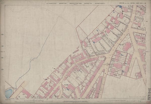
This map features Top left: n/a [blank] Top right: Pitsmoor Road, Nottingham Street, Forton Lodge, Throstle Grove, Vicarage [Christ Church Pitsmoor], Wood Fold, Woodside House, Brittain Villas, Great Rocks Villas, Christ Church Road, Christ Church [Pitsmoor], Pilgrim Street. Bottom left: Rutland Road, [Woodside Board] School (Boys), Playground, Woodside Lane, Birley Street, Mission Hall. Bottom right: Woodside Lane, Mission Hall, Pitsmoor Road, Nottingham Cliff, Nottingham Street, Wood Fold, [Burngreave] Congregational Church, Sunday School, Haddon Terrace, Haywood Road, Fowler Street, [Nottingham Cliff] Recreation Ground, Rising Street. Dimensions 77 x 102 cm. Scale 10.56 feet : 1 mile [1:500]. Original at Sheffield City Archives. |
Copying and access
This digital image, and all images on Picture Sheffield, are protected by copyright. You may use it for private study or non-commercial research, with due acknowledgement.
You may share it on social media via a linked post or by citing www.picturesheffield.com together with the Image Reference, unless its copyright is noted as belonging to another organisation. You must not reproduce it by any other means without permission.