Record Detail
| arc07564 | |
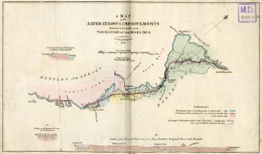
| Map of alterations and improvements intended to be made in the navigation of the River Dun | |
| Doncaster Kirk Sandall | |
| 1820 | |
| 1800-1850 | |
By W. and J. Fairbank. Show present course of the river (blue) and proposed cuts and diversion (red). Left to right: Wheatley, Bentley cum Arksey, Copleys Close, West Ratch, wear [weir], Long Sandall, Arnold Goight, Wait House, Kirk Sandall, Thorpe Marsh, ferry, ford, Barnby Dun, gravel pit, Wilsick House, Trumfleet Marsh, ferry, wear [weir], ford Stainforth Cut, South Bramwith. Also shows section of the proposed diversion of the river at Long Sandall, section of the cuts near the first West Ratch, and also a section of the proposed diversions from Long Sandall to Stainforth Cut at South Bramwith. Original at Sheffield City Archives: MD1097/3 (No. 3) (altRefNo MD1099 No. 3) |
Copying and access
This digital image, and all images on Picture Sheffield, are protected by copyright. You may use it for private study or non-commercial research, with due acknowledgement.
You may share it on social media via a linked post or by citing www.picturesheffield.com together with the Image Reference, unless its copyright is noted as belonging to another organisation. You must not reproduce it by any other means without permission.
