Record Detail
| arc04459 | |
| Lands in the Township of Ecclesfield lately under Lease to William Carleil | |
| Sheffield_Ecclesfield | |
| 1784 | |
| 1500-1799 | |
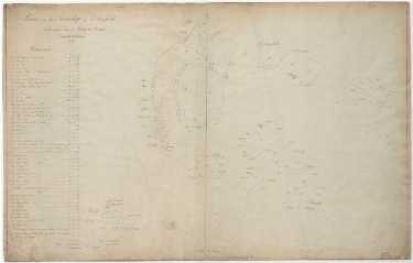
Scale 4 chains : 1 inch [20 inches : 1 mile]. Surveyor: William Fairbank II. Land between Lee Shrogs Wood and Church Lane, between Church Lane and the Travellers Inn, and east of Yew Lane, and at Grenoside, between Wheata Wood and Greno Common; Includes Ecclesfield Hall and Ecclesfield Paper Mill. Marked Grennowsode [Grenoside], Wheata Wood, Grennow Common, Prior Royd, Ecclesfield Hospital land, charity land, Ecclesfield Common, Sheffield Charity School, free land, poor, Aston, Loke Cross a field, Pinfold Field, Tunhill Field, Ecclesfield Charity, Jos. Tingle, Joseph Hobson, Widow Elliott, John Stacey, John Shaw, Edward Moore, H. Freeman, - Nath. Mellor, John Mellor, John Lockwood, John Wingfield, Robert Johnson, Matt. Stringer, Esther Yeardley, Thomas Moore, John Shirecliffe. Numerical list with field names and descriptions and acreages: 1 Low Shroggs (wood fenced in), 2 Starnell Lee, 3 Six Acre, 4 Three Acres, 5, Nether Shrogs (wood fenced in), 6 Four Acres, 7 Bog Lee or Eight Acres, 8, Watering Dike Lane from No. 16, 9 Lee Shrogs (w wood fenced in), 10 Lee, 11 Lee Bron [or Brow], 12 Denby Yard, 13 The Lee, 14 road at the bottom of The Lee, 15 House, garden, orchard, etc, 16 Farm yard with the barns, etc, 17 House, outhouses, fold garden, etc, 18 Lathe Croft, 19 Lane leading to the Damm, 20 Hanging Lee, 21 Intake, 22 A wood, 23 Damm, 24 House, gardens and croft, 25 Mill with the stable, Damm, and close adjoining, 26 Copping Lands including the woody parts, 27 Dog Up Lane Close including the road crossing it, 28 Two Acres, 29 Ash Flatt, 30 Upper Flatt, 31 Nether Flatt, 32 Middle Ing, 33 Upper Lady Croft, 34 Nether Lady Croft, 35 Upper Lownd, 36 Nether Lownd, 37 Hollow Hartley, 38 Three Nook'd Close, 39 Farrier Park, 40 Potato Piece, 41 Paddock, 42 Rough Close, 43 New ground, 44 House Field, 45 House with the Well Coft, etc., 46 Calf Croft, 33 Part of Upper Lady Croft occupied by Housley Freeman, esquire, Edward Moores freehold close lying betwixt Lee Bron [or Brow] and Starnell Lee Dimensions approx. 95 x 61 cm. Original at Sheffield City Archives: ACM/MAPS/16/15 (altrefno ACM/MAPS/Ecc/226L) Digitised with financial support from Sheffield and District Family History Society in memory of Professor David Hey (1938-2016) founder and life president of the Society. |
Copying and access
This digital image, and all images on Picture Sheffield, are protected by copyright. You may use it for private study or non-commercial research, with due acknowledgement.
You may share it on social media via a linked post or by citing www.picturesheffield.com together with the Image Reference, unless its copyright is noted as belonging to another organisation. You must not reproduce it by any other means without permission.
