Record Detail
Large format version available - click on Zoom button to browse this image in a zoomable viewer
| arc03417 | |
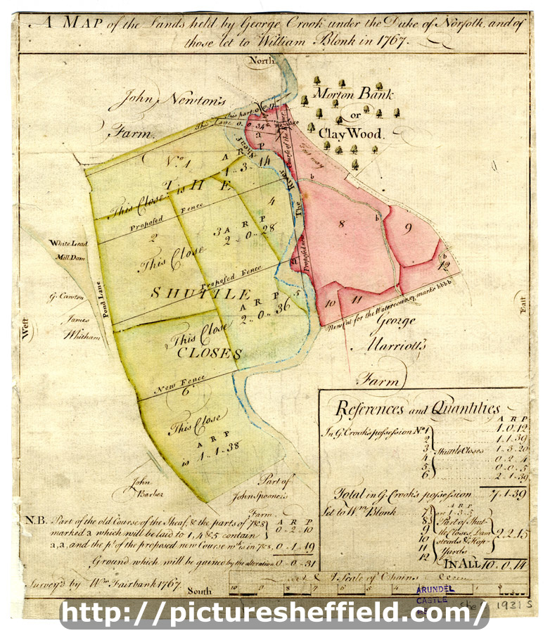
| A map of the lands held by George Crook under the Duke of Norfolk and of those let to William Blonk in 1767 | |
| Sheffield_City_Centre | |
| 1767 | |
| 1500-1799 | |
Scale 2 chains : 1 inch. Surveyor: William Fairbank II. The Shuttle Closes between the Lead mill dam and goit and the Sheaf, with some fields on the east side of the Sheaf; Morton Bank (Clay Wood); proposed new course of the Sheaf with reallotment of land shown and acreages listed; numerical list with tenants, field names and acreages; colours distinguish tenancies. White Lead Works and the fields between the Porter and the Sheaf, on either side of (modern Leadmill Road) Suffolk Road, Suffolk Lane, Sufflk Road, Granville Street, Rodley Lane, Cross Turner Street, Fornham Street, Shrewsbury Road, Pond Street (south end), St Mary's Road. [F.B. 32, pp. 12-13] B, p. 59. Dimensions: 25 x 28.5 cm. Original at Sheffield City Archives: ACM/MAPS/SheS/1931s. Digitised with financial support from Sheffield and District Family History Society in memory of Professor David Hey (1938-2016) founder and life president of the Society.
|
Copying and access
This digital image, and all images on Picture Sheffield, are protected by copyright. You may use it for private study or non-commercial research, with due acknowledgement.
You may share it on social media via a linked post or by citing www.picturesheffield.com together with the Image Reference, unless its copyright is noted as belonging to another organisation. You must not reproduce it by any other means without permission.