Record Detail
Large format version available - click on Zoom button to browse this image in a zoomable viewer
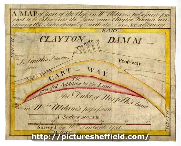
| arc03303 | |
| A map of part of the Close in William Aldam's possession proposed to be taken into the Lane near Clayton Damm containing 166 superficial yards, with the lane, etc adjoining | |
| Sheffield_Netherthorpe | |
| 1751 | |
| 1500-1799 | |
Scale 10 yards : 1 inch [88 inches : 1 mile] Surveyor: William Fairbank II. A simple plan including only the cartway and additions, a footway, a potato-piece and the Butts in Clayton dam; Measurements of additions Outlines and border coloured. Kelham / Kellam Wheel (also known as the Clayton Dam; this was on the River Don near Green Lane). A, pp. 49a-b. Dimensions 17.5 x 14.5 cm. Original at Sheffield City Archives: ACM/MAPS/SheS/1802s. Digitised with financial support from Sheffield and District Family History Society in memory of Professor David Hey (1938-2016) founder and life president of the Society.
|
Copying and access
This digital image, and all images on Picture Sheffield, are protected by copyright. You may use it for private study or non-commercial research, with due acknowledgement.
You may share it on social media via a linked post or by citing www.picturesheffield.com together with the Image Reference, unless its copyright is noted as belonging to another organisation. You must not reproduce it by any other means without permission.