Place the cursor on an image to see its title. Click to enlarge and obtain more information.
Click on add to album to keep a working record of the images you are interested in |
Place the cursor on an image to see its title. Click to enlarge and obtain more information.
Click on add to album to keep a working record of the images you are interested in |

![View: arc02632 A map of the Lownd Closes [Lound] near Chapel Town [Chapeltown] belonging to Saintforth Wroe, [1769] - 1783](https://www.picturesheffield.com/imagefiles/jpgs_sheffield2//arc02632.jpg)
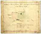
![View: arc02633 A plan of Samuel Smith's Cottage at Chapeltown and of the adjacent Freehold parts of his tenement there in which the cottage part is coloured green ..., [18th cent]](https://www.picturesheffield.com/imagefiles/jpgs_sheffield2//arc02633.jpg)


;)
;)
;)
;)
;)
;)
;)
;)
;)
;)