Record Detail
Large format version available - click on Zoom button to browse this image in a zoomable viewer
| q00056 | |
| Ordnance Survey Map, sheet no. Yorkshire No. 294.7.12 | |
| Sheffield_Crookes | |
| 1889 | |
| 1851-1899 | |
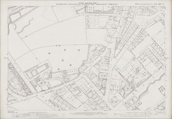
This map features Top left: Old quarry, Hands Lane, Bowling Green on corner of Hands Lane and Townend Street, [Ramsey Road], [Leamington Street], [site of Westways Primary School] Top right: Hands Lane, Commonside, Bower Road, Barber Road, Barber Crescent, Barber Place, Vincent Road, Beehive Road, Warrington Road, Spring Hill Road, Hands Houses, Moorend Terrace, Eveline Villas, Clifton Parade, Studley Villas, Leopold Villas, Hallamshire House Public House, Hands Row, Hazeldean, [The Nook]. Bottom left: Western Road, Conduit Road, School Road, Spring View, Spring Villa, Spring House, Cobden View Road. Bottom right: Commonside, Springhill Road, Warrington Road, Bower Road, Spring Hill Villas, Spring Hill, Rockville, Thorn Bank, Arnold Villas, Durer Villas, Spring Cottages, Ebor Villas, Spring Cottage, Calton Lodge, Moor Gate, Harcourt Road, Crookesmoor Road, Hiawatha Villa, Minnehaha Villa, Croydon Villas. Dimensions 77 x 102 cm. Scale 10.56 feet : 1 mile [1:500]. Original at Sheffield City Archives.
|
Copying and access
This digital image, and all images on Picture Sheffield, are protected by copyright. You may use it for private study or non-commercial research, with due acknowledgement.
You may share it on social media via a linked post or by citing www.picturesheffield.com together with the Image Reference, unless its copyright is noted as belonging to another organisation. You must not reproduce it by any other means without permission.