Record Detail
Large format version available - click on Zoom button to browse this image in a zoomable viewer
| q00055 | |
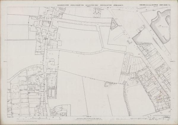
| Ordnance Survey Map, sheet no. Yorkshire No. 294.7.11 | |
| Sheffield_Crookes | |
| 1889 | |
| 1851-1899 | |
This map features Top left: Unnamed road [later called Crookes], Unnamed road [later called Toyne Street], New Lane [Newent Lane], Long Walk, [Stannington View Road], [Duncan Road], [Springvale Road]. Top right:Unnamed road [later called Toyne Street], New Lane [Newent Lane], Springvale Road, Western Road, Cobden View Road, Rollinsford [house], [Crookes Church] Mission Room on Cobden View Road, Cobden Terrace, Old quarry. Bottom left:Unnamed road [later called Crookes], Prospect Terrace, Crookes House, Ball Public House, Albine Terrace, Smithy (x2), Mule House Lane [Mulehouse Road], Springfield House, [Tasker Road], [Sackville Road], Bottom right:Cobden View Road, Cobden Terrace, Cobden View Hotel Public House, St. Thomas’s Vicarage, Cobden Place, School Road, Bay Terrace, old quarry, Sandhurst House. Dimensions 77 x 102 cm. Scale 10.56 feet : 1 mile [1:500]. Original at Sheffield City Archives.
|
Copying and access
This digital image, and all images on Picture Sheffield, are protected by copyright. You may use it for private study or non-commercial research, with due acknowledgement.
You may share it on social media via a linked post or by citing www.picturesheffield.com together with the Image Reference, unless its copyright is noted as belonging to another organisation. You must not reproduce it by any other means without permission.