Record Detail
Large format version available - click on Zoom button to browse this image in a zoomable viewer
| q00044 | |
| Ordnance Survey Map, sheet no. Yorkshire No. 294.4.22 | |
| Sheffield_Burngreave | |
| 1889 | |
| 1851-1899 | |
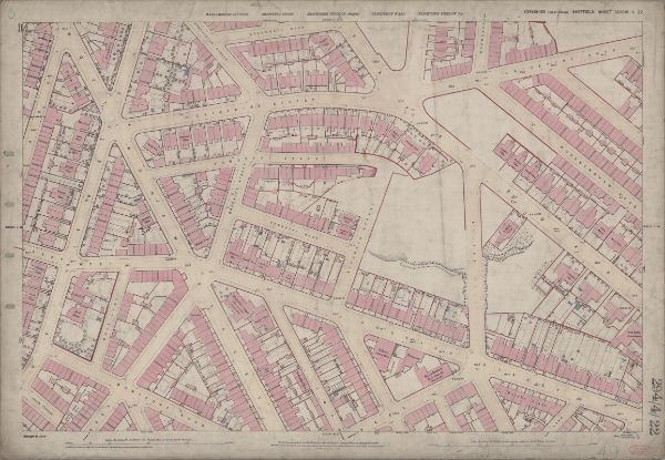
This map features: Top left: Rock Street, Nottingham Street, Brackley Street, Somerset Road, Catherine Street, Somerset Street, Leicester Villas, Fox Street, Cranworth Road, Brotherton Street, Cliff Rise, Recreation Ground, Farm Bank, Augusta Villas, Cranworth Place, Britannia Villas, Crossby Place, Elgin Place, Oakley House, Marchmount House, Douglas Villas, Princess Villas, Kingston Villas. Top right: Somerset Road, Catherine Street, Somerset Street, Kilton Hill, Burngreave Road, Richmond Street, Burngreave Road Police Station, Rutland Villas, Somerset View, Catherine Road,Burngreave Bank, Bressingham Road, Burngreave Street, Sandon Villas, Somerset Villas, Arundel Villas, Portland Villas, Storth Villas, Ditchingham Road, Kingston Villas. Bottom left: Rock Street, Nottingham Street, Brackley Street, Somerset Road, Leicester Villas, Montfort Road, Andover Street, West Andover Street, Lopham Street, Rock Lane, [Andover Street Methodist Church] Methodist New Connexion Chapel (junction of Nottingham Street and Andover Street), Sunday School, Hope Villa, Nottingham Terrace, Post Office, Rock House, Clarendon Place, Beech Villas, Arundel Terrace, Helen Terrace, Fitzalan Street, Verdon Street, Manor View, Rock House, Clifton Villa, Russell Place, Palmerston Place, Blenkarn Place. Bottom right: Andover Street, Lopham Street, Kilton Hill, Burngreave Road, Richmond Street, Police Station, Rutland Villas, Somerset View, Somerset House, [St, Catherine’s] School (Boys & Girls), Andover Street, Playground, St. Catherine’s R.C. Church Presbytery, Montfort Street, Bramber Street, Stockton Street, Kilton Street, Kilton Lane, Brunswick Road, West Riding Police Station, Andover Street, Leamington Villa, Mona Villas, Hornby Place. Dimensions 77 x 102 cm. Scale 10.56 feet : 1 mile [1:500]. Original at Sheffield City Archives. |
Copying and access
This digital image, and all images on Picture Sheffield, are protected by copyright. You may use it for private study or non-commercial research, with due acknowledgement.
You may share it on social media via a linked post or by citing www.picturesheffield.com together with the Image Reference, unless its copyright is noted as belonging to another organisation. You must not reproduce it by any other means without permission.