Record Detail
Large format version available - click on Zoom button to browse this image in a zoomable viewer
| q00038 | |
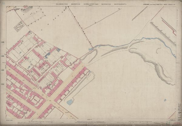
| Ordnance Survey Map, sheet no. Yorkshire No. 294.4.14 | |
| Sheffield_Grimesthorpe | |
| 1889 | |
| 1851-1899 | |
This map features: Top left: Meadow Head [?house], Carwood Lane. Added in pencil Carwood Terrace. Top right: Recreation Ground. Bottom left: Carwood Lane, Hallcar Terrace, Carwood Crescent (a row of terrace houses), Housley's Row, Petre Street, Carwood Lane, Jamaica Street, Canada Street, Mission Hall (Gospel Union) [White’s directory of 1896 lists Salvation Army Rooms in Canada Street]; added in pencil Carwood Crescent. Bottom right: Old quarry, Carlisle Street East. Dimensions 77 x 102 cm. Scale 10.56 feet : 1 mile [1:500]. Original at Sheffield City Archives. |
Copying and access
This digital image, and all images on Picture Sheffield, are protected by copyright. You may use it for private study or non-commercial research, with due acknowledgement.
You may share it on social media via a linked post or by citing www.picturesheffield.com together with the Image Reference, unless its copyright is noted as belonging to another organisation. You must not reproduce it by any other means without permission.