Record Detail
Large format version available - click on Zoom button to browse this image in a zoomable viewer
| q00034 | |
| Ordnance Survey Map, sheet no. Yorkshire No. 294.3.23 (full sheet) | |
| Sheffield_Walkley | |
| 1889 | |
| 1851-1899 | |
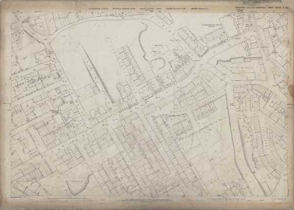
This map features: Top left: Whitehouse Lane, Hawksworth Road, Tennyson Road, Whitehouse Road, Tennyson Place, Prospect House, Creswick Street, Walkley Road, Industry Street, Albion Villas, Mona Villas, Hoole Street, Carr Road, Bellevue Inn, Arundel House. Top right: Whitehouse Lane, Burgoyne Road, Somerville Street, Fox Road, Kelvin Place, St. Bartholomew’s Church, Sunday School, Police Station, Brick Works, Brewery, White House Langsett Road, tramway, Ash Street, Crown Brewery, Luther Terrace, Mona Villas, Mortar Mills, York Place, Cyprus Terrace, Methodist Chapel, The Wellington Public House, Grammar Street, Parkin Street, Wood Street. Bottom left: Burgoyne Road, Whitehouse Road, Tennyson Road, Albion Villas, Otley Street, Harold Street, Bloor Street, Harworth Street, Old Quarry, Arundel House, [Walkley] Methodist Chapel (Cundy Street), Cundy Street, Hoole Street, [Burgoyne Road] School, Playground (x2), Elton Street. Bottom right: Burgoyne Road, Somerville Street, Fox Road, Kelvin Place, York Cottage, Kelvin Street, Jenkinson Street, Woollen Lane, Sheard Road, Fern Villas, Otley Street, Hardy Street, Somerville Terrace, Harold Street. Dimensions 77 x 102 cm. Scale 10.56 feet : 1 mile [1:500]. Original at Sheffield City Archives. |
Copying and access
This digital image, and all images on Picture Sheffield, are protected by copyright. You may use it for private study or non-commercial research, with due acknowledgement.
You may share it on social media via a linked post or by citing www.picturesheffield.com together with the Image Reference, unless its copyright is noted as belonging to another organisation. You must not reproduce it by any other means without permission.