Record Detail
Large format version available - click on Zoom button to browse this image in a zoomable viewer
| q00033 | |
| Ordnance Survey Map, sheet no. Yorkshire No. 294.3.22 (full sheet) | |
| Sheffield_Walkley | |
| 1889 | |
| 1851-1899 | |
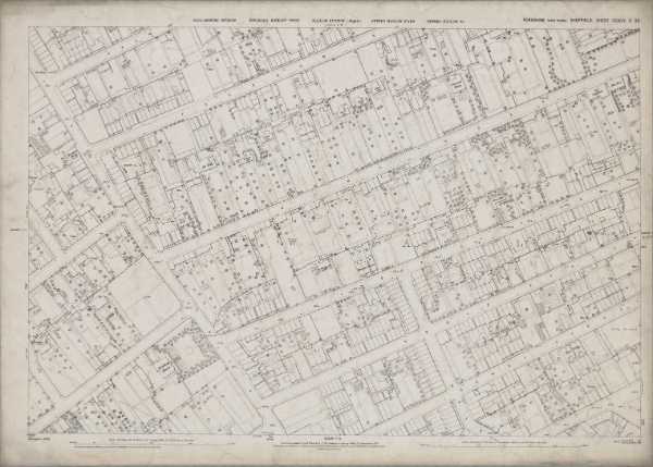
This map features: Top left: South Road, Carr Road, Highton Street, Orchard Road, Freedom Road, Palm Street, Freedom House Public House, Nelson House, Melrose Villas, Fir Villa, Victoria Villa, Laurel Grove, Gringley Villa.Top right: Carr Road, Freedom Road, Quarry, Freedom Road, Industry Street, Sherwood House, The Hawthorns, The Firs, Myrtle Villa, Bicton Villa, Orange Villa, Oak House, Pitsmoor View, Sunny Bank.Bottom left: South Road, Carr Road, Highton Street, Orchard Road, Industry Street, Hoole Street, Greenhow Street, Walkley House, Camm’s Well, Camm Street, Fir Street.Bottom right: Industry Street, Hoole Street, Walkley Street, Cundy Street, Fern Villas, Burgoyne Road, Elton Street, Bellehaye Terrace, Smithy.Dimensions 77 x 102 cm.Scale 10.56 feet : 1 mile [1:500].Original at Sheffield City Archives. |
Copying and access
This digital image, and all images on Picture Sheffield, are protected by copyright. You may use it for private study or non-commercial research, with due acknowledgement.
You may share it on social media via a linked post or by citing www.picturesheffield.com together with the Image Reference, unless its copyright is noted as belonging to another organisation. You must not reproduce it by any other means without permission.