Record Detail
Large format version available - click on Zoom button to browse this image in a zoomable viewer
| q00031 | |
| Ordnance Survey Map, sheet no. Yorkshire 294.3.19 (full sheet) | |
| Sheffield_Neepsend | |
| 1889 | |
| 1851-1899 | |
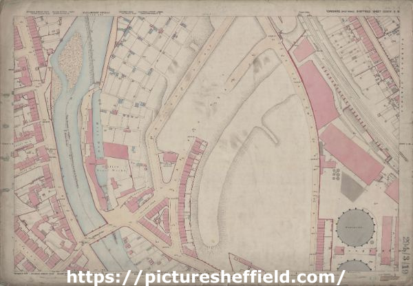
This map features: Top left: River Don, weir, Hoyland Road, Farfield Road, Grove Row, Penistone Road, Mill Dam, Club Mill Road, Grove Cottage, Hicks Road, Fawley Road, Grove Square, Stone Yard. Top right: Hoyland Road, Farfield Road, Park Wood Road, Manchester, Sheffield and Lincolnshire Railway, Orchard Terrace, Wallace Road, Neepsend Station. Bottom left: River Don, Hoyland Road, Farfield Road, Penistone Road, Mill Dam, Club Mill Road, Clifton Steel Works, [Neepsend United Methodist Church] Methodist Chapel (Farfield Road), Hillfoot Road, Hillfoot Bridge, The Minerva Public House (Penistone Road), Hillfoot Works, Smithy, Clifton Hotel, Neepsend Lane, Wood Street, Lime Street, Ash Street, [Penistone Road] Post Office. Bottom right: Park Wood Road, Manchester, Sheffield & Lincolnshire Railway, Neepsend Gas Works. Dimensions 77 x 102 cm. Scale 10.56 feet : 1 mile [1:500]. Original at Sheffield City Archives. |
Copying and access
This digital image, and all images on Picture Sheffield, are protected by copyright. You may use it for private study or non-commercial research, with due acknowledgement.
You may share it on social media via a linked post or by citing www.picturesheffield.com together with the Image Reference, unless its copyright is noted as belonging to another organisation. You must not reproduce it by any other means without permission.