Record Detail
Large format version available - click on Zoom button to browse this image in a zoomable viewer
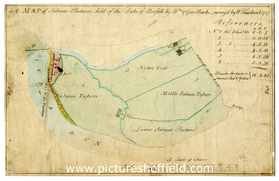
| arc02667 | |
| A map of Salmon Pastures held of the Duke of Norfolk by Wm. and Geo. Binks | |
| Sheffield_Attercliffe | |
| 1787 | |
| 1500-1799 | |
Scale 3 chains : 1 inch [26.6 inches : 1 mile].Surveyor: William Fairbank II.Between Warren Street and the goight and the Don; closes, etc., numbered and listed with particulars.Includes the Nether Field and the old wheel; numerical list with acreages; field names given on the map. Royds Mill and Farm.F.B. 63, supp., p. 72 64, p. 7C, p.51.Dimensions: 28.5 x 18 cm.Original at Sheffield City Archives: ACM/MAPS/SheD/751S.Digitised with financial support from Sheffield and District Family History Society in memory of Professor David Hey (1938-2016) founder and life president of the Society. |
Copying and access
This digital image, and all images on Picture Sheffield, are protected by copyright. You may use it for private study or non-commercial research, with due acknowledgement.
You may share it on social media via a linked post or by citing www.picturesheffield.com together with the Image Reference, unless its copyright is noted as belonging to another organisation. You must not reproduce it by any other means without permission.